
|
HASKIN'S POINT
For over two centuries, Haskin’s Point has been the scene of the ‘summer action’ at Seeley’s Bay. All Rideau Canal boat traffic passes within a few feet of its shoreline. Located at the end of a peninsula forming the south shore of Seeley’s Bay, Haskin’s Point is an outcropping of Canadian Shield rock known as the Frontenac Arch. The ‘Point’, as it is known to locals who favour it as a swimming spot, marks the entrance to Little Cranberry Lake to the south of Seeley’s Bay with Broad’s Bay to the southeast. Local legend insists that from the mid-1820s through canal construction, a trading post (in the form of a tepee) was available here for itinerant paddlers. The legend also holds that the trading post was operated by ‘Granny (Ann) Seeley’, one of the first settlers living at the Seeley’s Bay site. |
Named after Samuel Haskin who purchased the lot in 1840, Haskin’s Point provided a landing wharf and refueling stop for the steamboat traffic plying the Rideau throughout the nineteenth century. Several other businesses, including a general store and potashery operated during the mid-century. Huge piles of fuel wood on the shoreline encouraged the establishment of businesses and settlement in the mid-1840s. After the flooding of the canal route through Little Cranberry Lake, the village site became accessible to steamboats as the flooded tree stumps and dense tangle of cranberry marsh were gradually cleared. Until the 1860s Haskin’s Point was an important forwarding centre receiving products such as potash, wheat, pork, butter, cheese and potatoes for transportation to markets up and down the canal.
Visitors standing on the Point today enjoy a view of the entrance to Little Cranberry Lake to the south and one of the finest panoramas of the history of cottage architecture offered along the canal route. From the 1880’s until 1986, a two-car, hand-operated ferry crossed the canal from the Point to Hewitt Island. Across from the Point on the island can be seen one of the canal’s oldest fishing cottages, an original stone building constructed in 1911 and still in use today by the fifth generation of the Hewitt family. Looking in both directions from the Point, one sees cottage architecture from the early 20th century to today’s retirement cottage homes. Along the peninsula leading to the Point from the village itself are several cottage resorts, established mostly for American fishermen in the 1940’s to 1960’s, and still providing active resort life for today’s tourist.
Visitors standing on the Point today enjoy a view of the entrance to Little Cranberry Lake to the south and one of the finest panoramas of the history of cottage architecture offered along the canal route. From the 1880’s until 1986, a two-car, hand-operated ferry crossed the canal from the Point to Hewitt Island. Across from the Point on the island can be seen one of the canal’s oldest fishing cottages, an original stone building constructed in 1911 and still in use today by the fifth generation of the Hewitt family. Looking in both directions from the Point, one sees cottage architecture from the early 20th century to today’s retirement cottage homes. Along the peninsula leading to the Point from the village itself are several cottage resorts, established mostly for American fishermen in the 1940’s to 1960’s, and still providing active resort life for today’s tourist.
|
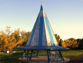
HISTORY OF THE TIPI IN CENTENNIAL PARK
The name Seeley’s Bay comes from Ann Seeley who was the owner and occupant of Lot 4, on the 8th Concession of Leeds, when the Rideau Canal was completed and the bay flooded. Ann was the second wife of Justus Seeley who was an innkeeper from Elizabethtown Township. Justus’s son, John, who lost an arm in the Battle of Lundy’s Lane during the War of 1812, had obtained title to Lot 4 in the eighth concession of Leeds, as heir of his mother, Matilda Read, to whom it was originally granted. |
Rather than have John face clearing a wilderness lot with only one arm, father and son appear to have traded property, with John running the inn in Elizabethtown, while Justus, Ann and at least one child, moved onto the lot in Leeds in 1824. After Justus Seeley died in 1830, Ann remained on the lot which eventually passed into the hands of her daughter Charlotte and her husband Matthew Bebee. Part of the land that the Seeleys owned was flooded when the canal was completed in 1832, and the bay that was created by the flooding, and later the village, became known as Seeley’s Bay.
Local lore suggests that after the Seeleys established themselves on their land they built a structure resembling an aboriginal tepee from which they ran a trading post or store, doing business with local aboriginals and European settlers in turn. When Canada celebrated its 100th birthday in 1967 a new park was established along the Haskin’s Point Road which was named Seeley’s Bay Centennial Park. At that time a group of local citizens formed a Centennial Committee to plan special events for the community, and they decided to build a large tipi in the new park that would replicate the trading post from which the Seeley family did business 140 years earlier. An antenna was erected on the peak of the tepee and inside was placed the epitome of modernity at that time – a colour television set. Hence was born the motto of the local centennial celebration – ‘Tipi to T.V.’
The Seeley’s Bay tipi continued to be a focal point and a landmark of the community until 2019 when due to a structural safety issue it had to be taken down. The community looks forward to a new multipurpose structure to be built in Centennial park in the near future..
|
BROAD'S BAY
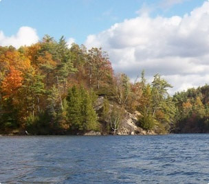
The story of Broad’s Bay is one of a dramatic transformation of the natural environment engineered by human workmanship. Visitors from paddlers to cross-country skiers will appreciate the efforts of Lieutenant-Colonel John By’s Royal Engineers and the Irish workmen who turned a stinking bog into a beautiful, rural village landscape with public water access – surrounded by loon calls, the splash of beaver tails and rising fish. A Rideau canal boat trip through the main channel of Little Cranberry Lake, or the view south-west from Haskin’s Point, reveals Broad’s Bay, named after George Broad whose family had established a home at the village site by 1840. This wide-mouthed, pristine bay is now a haven for anglers and wildlife alike. |
Not so, however, in the 1820’s when John McTaggart, clerk of By’s canal works at the time, described this bay as “an infernal place… where the mist of the marsh is extremely noxious to life”. Today its birdsong, tranquility and majestic sunsets are sure to improve any visitor’s quality of life. In fact, the 18 mile long floating cranberry marsh in the Seeley’s Bay area was one of the most difficult obstacles to overcome in making the Rideau route navigable. It was probably in this area of Broad’s Bay where, on a canal inspection trip in 1828, Lieutenant-Colonel John By became lost in the tangle of floating cranberry roots and was stranded in his canoe overnight with “only the call of the loons for company”. Although the cranberry bog is long gone, downed by boat-loads of stone to make the canal and Seeley’s Bay navigable, visitors to Broad’s Bay are invited to share John By’s paddling route where the loon calls still echo over Little Cranberry Lake.