
|
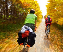
There is some good cycling in the area. Start in the park (washrooms are available) and pick up any necessities before heading out at our local businesses. The Nest Egg is designated a bike friendly destination meaning Dale has some emergency equipment (ie. a bike pump, water, etc) if you run into trouble.
FORGOTTEN ONTARIO CYCLE ROUTE This is a very pretty bike route although the 8km of hills on Burnt Hills Road can be quite challenging especially early in the season. There are lots of picturesque stops along the way where you can stop for a drink or some rest. |
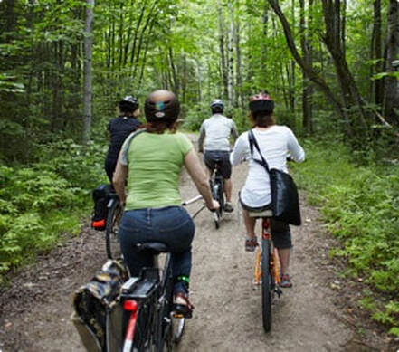
Public washrooms are available in Centennial Park at your starting spot in Seeley’s Bay. If it is a hot day – a dip in Cranberry Lake off Haskin’s Point is a must do (about 1km from the park). Thank you Ken Watson for letting us use your well researched routes. We’ve ridden these routes and they are very accurate.
|
|
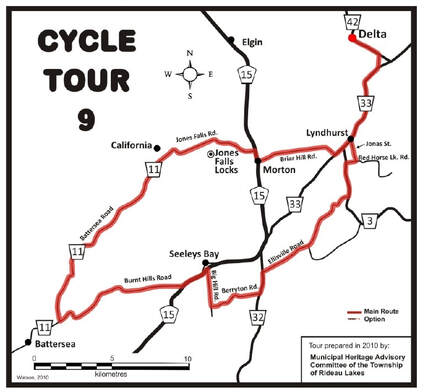
Approximately 76km with about 10% gravel roads
Start Location:1. (44º 27.962’N. 76º 15.303’W.) Turn Left onto Hwy. 15. toward Big Hill Rd. CAUTION; Hwy. 15 can be very busy.
2. (44º 28.396’N. 76º 14.169’W.) Turn Right onto Big Hill Rd. onto gravel toward Berryton Rd. (Big Hill Rd. ends; no sign post, only a Stop Sign)
3. (44º 27.290’N. 76º 13.980’W. ) Turn Left onto Berryton Rd. (gravel) toward Hwy. 32 (Berryton Rd. ends; no sign post, only a Stop Sign)
4. (44º 27.733’N. 76º 11.680’W.) Turn Left onto Hwy.32 toward Ellisville Rd.
5. (44º 28.390’N 76º 11.515’W.) Turn Right onto Ellisville Rd. toward County Rd. 3. At Km. 59.1 (44º 29.340’N. 76º 09.362’W.) turn left at Ellisville (signpost Ellisville Road, Lyndhurst) onto unpaved road. Pass Circle H Ranch and Grippen Lake Camp. Ellisville Rd. ends at STOP Sign onto County Road 3 on west side of Singleton Lake.
6. (44º 31.055’N. 76º 07.450’W.) Turn Left onto County Rd. 3 (paved) toward Red Horse Lake Rd.
7. (44º 32.195’N. 76º 07.585’W.) Turn Right onto Red Horse Lake Rd. (unpaved) toward Jonas Street.
8. (44º 32.254’N. 76º 07.106’W.) Turn Left onto Jonas Street (unpaved) toward Oakel Rd. Pass by Lyndhurst Lake and over Lyndhurst Creek
9. Turn Right onto Oakel St. in the village of Lyndhurst toward Ford Street. Then Turn left onto Ford Street toward County Rd. 33. The scenic and heritage community of Lyndhurst, once a thriving mill town, is famous for its stone arch bridge.
10. (44º 33.065’N. 76º 07.380’W.) Turn Right onto County Rd. 33 toward Hicock Rd.
11. (44º 35.463’N. 76º 05.921’W) Turn Left onto Hicock Rd. toward Hwy. 42.
12. (44º 35.983’N. 76º 05.987’W.) Turn Left onto Hwy. 42 toward Delta.
13. (44º 36.600'N. 76º 07.330'W.) Welcome to the Historic Old Stone Delta Mill. It is a National Historic Site. There are restaurants and stores in Delta. Note the many fine heritage homes in this community founded on the headwaters of the Gananoque River System over 2 centuries ago. Delta was the site of one of the first Temperance societies in British North America. Head South on Main Street (County Road 42)
15. (44º 35.990’N. 76º 05.985’W.) Turn Right (S.W.) onto Hicock Rd. toward County Rd. 33. (Hicock Rd. ends; no sign post, only a Stop Sign)
16. (44º 35.458’N. 76º 05.927’W.) Turn Right (Westerly) onto County Rd. 33 toward Briar Hill Rd. Peddle through the heritage community of Lyndhurst, once called Furnace Falls.
17. (44º 32.532’N. 76º 08.149’W.) Turn Right onto Briar Hill Rd. toward Hwy. 15 at Morton. Briar Hill Road makes a sharp left bend. Do NOT go straight onto “Old Briar Hill Rd”. Fertile fields among outcrops of Shield and onto the floodplain of once Whitefish Creek. Pass the intersection with Fortune Line, named after the surveyor that defined this “townline”.
18. (44º 32.259’N. 76º 11.873’W ) Turn Right onto Hwy. 15. CAUTION; Hwy. 15 can be very busy.
19. (44º 32.520’N 76º 11.900’W.) Turn Left onto Jones Falls Rd. (County Rd. 11). Stop at Jones Falls, a UNESCO Heritage Site – Parks Canada – Rideau Canal.
20. Hotel Kenney Road, turn left at 44º 32.790’N. 76º 13.960’W. Jones Falls Locks and Great Arched Dam. Rideau Canal - a National Geographic destination.
21. Jones Falls Dam Rd., turn at 44º 32.960’N. 76º 14.080’W. To the Great Arched Dam. Continue peddling the pavement across the bridges over the Rideau and along County Rd. 11. You are now in California. Once there was a thriving community with a church, a cheese factory and several prosperous farms. Stay on the pavement in spite of the construction. Follow the main road as it veers to the right into South Frontenac Township on the Battersea Rd., “The Old Stage Road”. You want hills and curves? You get hills and curves aplenty here in the Frontenac Axis.
22. (44º 30.881’N. 76º 17.651’W.) Bear Left onto the Battersea Rd.toward Burnt Hills Rd. This road is very winding and hilly with narrow pavement You will get a true sense of Canadian Shield – Frontenac Axis geology and geography.
23. (44º 26.675’N. 76º 21.500’W.) Turn Left onto Burnt Hills Rd. toward Hwy 15. At Km. 45.2 cross the Brass Point swing bridge over the Rideau Canal. Knapp’s Camping area, picnics snacks, etc.
24. (44º 27.962’N. 76º 15.303’W.) Turn Left onto Hwy. 15. toward Big Hill Rd. CAUTION; Hwy. 15 can be very busy. You are now back in Seeley's Bay.
Distance: 76km
Bike Suitability: Experienced Rider
Notes and Cautions:Be Alert on HWY 15 especially there are some pot holes.